My Local Buy Story - Geo Scan 3D
Feature article by Craige Hills and Mark Stanley of Geo Scan 3D
Local Buy have opened so many opportunities for us since becoming a supplier. Introducing such new technology to the market can be a challenge. Local Buy shares the passion to be innovative and be at the forefront, introducing new services to consumers knowing it will make a positive impact on all organisations.
Thank you to Audrey, Emma and the Local Buy team.
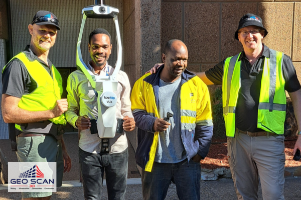
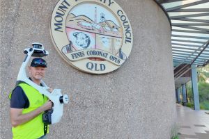
Geo Scan3d have recently partnered with Mt Isa City Council in a pilot project to capture some of the council’s assets including roads, parks and public buildings inside and out. Geo Scan 3D allows for highly accurate, three-dimensional mapping of urban spaces and complex buildings. This precision helps planning and maintenance of fixed assets enabling better data driven decisions on infrastructure projects, from new roads and bridges, parks and public spaces through to buildings and treatment plants. With this technology, we can visualise and simulate how new developments will integrate into existing areas, ensuring smarter and more sustainable growth.
Areas captured
- 800 metres of road
- Capture the newly upgraded Centennial Place
- Precinct carpark, riverwalk and vacant land
- Administration building
- Civic Centre
- Library
The deliverables were a complete digital twin of all the assets, able to be viewed on a desktop or mobile device. The digital twin can be viewed by any number of people within the organisation and shared to any professional of their choosing. Planning teams can collaborate on projects amongst themselves on site and virtually.
- Digital twins of all assets and hosted on cloud platform for anytime viewing of both indoor and outdoor spaces
- Condition assessment reports
- Existing and new line drawings of roadway mapped for surveyors to locate and use on new road surface
- Located points of interest within the digital twins, housing information such as
- equipment serial numbers, transformers and water meters
- 2D elevation models of park precinct and vacant land
- Slopes and levels on footpaths and crossings to comply with the Disability and
- Discrimination Act (DDA)
- Assessing and measurement of volumes required for roadway resurfacing against quoted/charged quantities
 Accuracy was a huge factor in delivering this project. After inserting survey control points throughout the scanned area then capturing these points throughout the scan we were able to produce 1.2 million survey grade points per second creating a digital twin of the assets. What they can do with this data now is mind blowing from just one scan.
The outcomes:
Mt Isa City Council now has a complete digital twin of all sites captured available to be viewed at any time in the future. Depending on the future outcome they require this data can be imported into any software, allowing them to produce the required outcome. The data easily integrates into the current ArcGIS system that Mt Isa City Council currently employs. However, since viewing the digital twin in several different platforms, staff are realising the huge potential of what is available and what can be achieved. The council is considering multiple options that will suit workflows and isolated requirements. By potentially adopting these new workflows benefits such as staffing productivity, reporting, data security, access to professional services throughout Australia at the fingertips, sharing any asset in a matter of seconds can now be realised.
Using data from the initial scan, Geo Scan 3D continues to work with Mt Isa City Council to extract further information, as required.
The cost savings of this piloted project were substantial. Budget blowouts and delays are proving to be a thing of the past. Geo Scan 3D was able to give Mt Isa City Council the required information weeks earlier than had traditional methods been used, particularly due to labour shortage and saving on expenses associated with engaging professionals from out of town to attend sites, inspect and report.
Geo Scan 3D captured all necessary information that was electronically sent directly to
required stakeholders and third-parties.
Mt Isa City Council has now embraced the way of the future by utilising Geo Scan 3D mobile scanning and mapping services and can now focus on allocating funds saved into other projects that had been put on the back burner.
 Since the data capture: the Mt Isa City Council have identified several other benefits. The road was resurfaced, and the contractor used had paved the new surface over the top of all existing sewer inspection points and road hydrant points. Initially it was considered an issue however having the survey grade data available we were able to locate the exact points to cut to insert the required risers to give a perfectly finished product.
Through the onboarding and training sessions that we conducted with all our clients we identified that items, looking to be purchased for kitchen upgrades was not able to fit through the doors therefore purchasing equipment that can be installed at minimal cost. This was all identified from a desktop planning out the project. This certainly frees up everyone’s time in traveling to site multiple times to measure and plan the projects.
During an Insurance claim, staff were able to identify areas of concern within the Civic Centre damaged floor, take photographic snapshots from the 3D database, determine and show graphically the true nature and size of the area to justify the extent of the claim. Being able to view the 3D model allows appropriate photographic shots to be snipped quickly supporting why estimates for sealing and cleaning due to sanding and coating of the replacement floor would be much higher due to the high volume and staging services above the theatre space.
Geoscan3D, is continuing to collaborate with the Mt Isa City Council in obtaining the best data hosting solutions to suit their needs. We test a vast array of new Lidar software solutions on the market and are therefore able to offer our clients timesaving advice on solutions that may suit them.
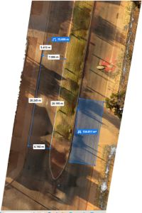
This particular project only took us 2 days to scan with about 120,000m2.
“We have only scratched the surface of what we can do with this data, and we continue to be amazed with the value-adding that the 3D model provides. I am considering further build-up of our 3D database to set Council up for the future. Being in a remote area this technology is a disruptor for traditional detail survey and will expedite the start-up of many projects,” said Rithy Poch, Manager Major Projects at Mt Isa City Council.
Geo Scan 3D can be found under our parent company of Spatial n Compliance through Local Buy Arrangement LB312.